Gazprom Neft: Achimov Strata Regional Model Used as a Tool for Building a New Geological Exploration Option Portfolio in West Siberia
Introduction
The West Siberia (WS) resource base needs to be replenished to maintain the current development indicators. The reserves associated with the classic structural traps have been identified and mapped as part of the major horizons developed across the WS area. The resource base replenishment from these reserves is ineffective because the traps are thin, or they occur at great depths, which negatively affects the resource base quality and their development economic efficiency.
Currently the Achimov strata is a resource base growth and reserve replacement driver as it is ubiquitous across West Siberia at the depths from 2500m to 3500m, genetically these are deep-water deposits
of fans. Bringing these deposits into development is advantageous due to their proximity with existing assets where production is performed from the above and below the geological objects; but it is complex due to the lithologic type of the traps and due to the extremely low exploration knowledge of the deposits across the WS area. Since this area’s Achimov deposits characteristics vary greatly, understanding their potential is hindered by a lack of proven drilling history in the area.
The work “The Regional Assessment and Zonal Study of the Achimov Sequence Potential Oil and Gas Bearing Capacity in the West Siberia” was carried out in Gazprom Neft to identify and assess the most prospective areas for bringing them into development.
The goal and objectives of this work are to develop a tool for searching and predicting the potential options (license areas for acquisition) using the existing regional maps based on various criteria (characteristic properties and their combinations) and using the data generalized over the entire West Siberian region.
The Method
The portfolio of the potential production options is the result of a series of studies, each of which was a logical continuation of the preceding one:
• Based on the West Siberian regional model, prospective areas were delineated for exploration (several regions were selected across various administrative districts);
• After ranking the targets in accordance with the set of selected criteria and considering the preferences from Gazprom Neft’s subsidiaries, several regional projects were launched to assess the areas located across multiple administrative boundaries and districts. After the zonal phase was finished the portfolio of the resource-rich license areas was generated;
• A geological and economic assessment was carried out in the higher priority license areas, to evaluate the development cost, considering the prospecting and exploration program that would be implemented. A detailed geological evaluation of the entire oil saturated layer was then carried out as part of the geological and economic assessment.
The work describes a methodological approach to developing the Achimov regional model with consideration of the geological, technological and economic risks.
The total activity area amounted to approximately 1.5mln. km2. Data from more than 5300 wells, the 2D regional seismic survey volume amounted to ~63,000 linear km, the 2D ariel seismic survey volume made up 263,000 linear km (shooting density ranged from 0.6 to 2 linear km/km2) was used.
The work involved core sampling analysis data from 198 wells using more than 20,000 samples, 800 capillary curves and 450 well tests. The integration and analysis of different scale maps (geological, technological and economic risk maps, the field data coverage maps and the prospectivity maps) were the major principles for selecting the potential options for commercial development.
Seismic Geological Correlation:
To link the seismic data and to understand the spatial position, the main reference regional horizons G, M, B, A were traced.
Further on, the Achimov distribution area was localized (about 1 mln sq.km). 14 clinoform complexes were traced, occurring in the base of the Neokomian in the form of echelon lense like masses of submeridional extension in stratigraphically sliding range, from the east of the Berriasian to the Hauterivian on the west. The sequence stratigraphy principles were applied in the selection process and a transgrassive clay unit was detected across the area controlling the Achimov sequence formation stage.
A similar approach was later suggested and defended by a team of authors such as S.A.Gorbunov, A.A.Nezhdanov, A.A.Spodobayev in their work “The Achimov Reservoir Uniform Indexation System Used in the PAO Gasprom License Areas in the Yamal-Nenets Autonomous District”. The transgression periods can be divided by age by way of entering indices within each selected age window (the clinocyclite in the regional model) which can divide targets with the desired level of detail, and enables a comparison with the delineated targets of various fields for a more specific search of their analogues. Additionally, work was carried out on assessing the accommodative space within the boundaries of the delineated clinocycles; the outcomes of that work were used while selecting the analogues.
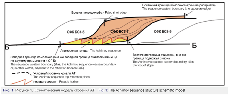
The methodology for detecting the conditional seismic horizon controlling the Achimov deposit upper boundary which enabled the mapping of the eastern and the western boundaries of the fondoform deposits and the indexation of each relevant cyclite (Figure 1).
Petrophysical Model:
The core sample data of 198 wells, using 20 thousand samples, was used to build the Achimov clinoform complex petrophysical model. Due to the large scale of this work, many petrophysical relationships considered each well’s location. In particular, the mapping of changes in the formation’s water salinity was built up to correctly evaluate the reservoir’s saturation behavior. The tests revealed some differences between the fluids in the northerly explored area (predominantly gas and gas-condensate inflows) and in the southwardly area (predominantly oil inflows there). The petrophysical model used various data sets from the saturated reservoirs which enabled a more accurate evaluation of the saturated rock volume. Based on the analysis, the Achimov sequence distribution area clustering was carried out using the differences in the reservoir and fluid properties, in order to selecting generic technological solutions for each relevant cluster.
Map Generation, Risk Evaluation:
The goal in this phase was to evaluate the quantity and quality of the resource base based on the field data coverage of each relevant region; then ranking each by priority and planning further appraisal projects for implementation.
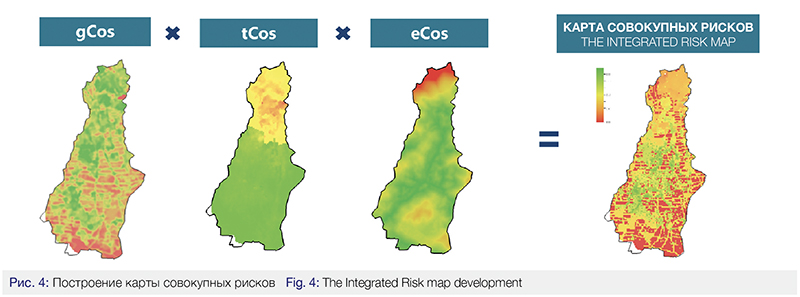
The following elements were fundamental for generating the prospecting map using the suggested methodology: the resource base quantity map, the resource base quality map, the risk map considering both geological (gCoS), technological (tCoS), and economic risks (eCoS). More than 45 regional scale maps were generated and analyzed in order to carry out the resource base evaluation, using the State Reserves Register, geological records, 2D seismic exploration materials and various wellbore data.
The list of major maps used for generating the integrate prospect map includes the following:
• The A,B,M (А, Б, М) reflection horizon structural maps of the entire exploration area;
• The clinocyclites structural maps;
• The Achimov sequence top structural maps;
• The Achimov sequence maps (gross, net pay, oil and gas saturated thicknesses)
• Maps with reservoir characteristics (porosity, permeability);
• Fluid property maps (density, gas content, share of the fluid type liquid HC/gas);
• Maps with the formation pressure, temperature and anomalous pressure data);
• The map of rock properties from Bazhenov Strata (paleotemperatures, present temperatures, HC maturity, etc)
• Paleographic maps (the Berriasian, the Early Valangian, the Late Valangian, the Hauterivian).
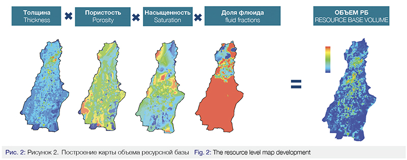
The resource quantity estimation (Figure 2) was carried out using the volumetric method for oil and for gas, consequently, using the discovered field data verification. The regional volumetric maps generated during this project were used as the initial data.
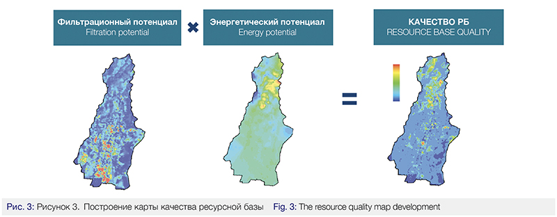
The quality resource base evaluation (Figure 3) was carried out by combining the reservoir filtration and the reservoir potential maps – the parameters that determine the individual well initial flow rate, according to the Dupuis formula.
The 5-factor analysis methodology was applied to evaluate the geological risks, estimating the geological chance for success, considering the source rock presence and maturity, the migration routes, the presence of reservoir, traps and cap rock.
The trap availability related risk magnitude (Рл) was determined by the degree of seismic knowledge, the research method accuracy (the mapping contour error control), the trap type, size and seal (structural, lithologic or stratigraphic one). A geological basis for this evaluation was served by the accurate contour map, as well as some other maps related to the Achimov sequence top, using the regional seismic exploration data across the area.
The reservoir presence related risk (Рк) was determined in accordance with the sedimentation conditions and the net pay prediction maps. The Achimov net pay zone maps were used to determine this parameter, developed on the seismic exploration and well data materials, as well as the paleographic maps of the relevantly aged clinocyclites were used.
The rock quality factor (Рс) was determined by the characteristics of cap rocks and the structural history of the region – the presence of tectonic dislocations, the gross thickness and the fluid seal quality, the remoteness from the stratigraphic pinchout line, as well as the presence of abnormally high formation pressure zones. The West Siberia tectonic map, the Pre-Mesozoic basement map and the anomalous pressure map were used as the geological basis. The key factor in this analysis, determining the rock quality, was the presence of faults from B to M.
The presence of oil and gas source rocks (РHN) in the area under consideration was determined using the following geological information: the organic matter maturity map, the oil generating potential map, the rock paleotemperatures map, the Bazhenov Strata rock present temperatures map, the map of the HC concentration mean values in the Bazhenov Strata sedimentations and its analogues, the HC catagenesis map. The thermal maturity (the catagenesis stage), the organic carbon content, as well as the fact that the HC fields were discovered in the neighboring areas served as the key parameters in determining the risk magnitude value.
The migration routes presence related risk (Рм) was evaluated using the same set of input information, characterized above, which was determined using the distance from a petroleum charge to a trap, and by the presence of faults as well.
Doing the regional evaluation, the probable factors complicating the drilling of hi-tech wells (horizontal well with multi-stage hydraulic fracturing), presently believed to be one of the major technologies for the Achimov sequence development, were seen as the technological risks. The Achimov sequence depth maps, the anomalous pressure maps and the formation pressure maps were used to evaluate those technological risks.
In order to evaluate the economic risks, the analysis was carried out to define the distance of development targets from the infrastructure facilities, such as: compressor stations, oil pumping stations, roads, oil, gas and condensate pipelines. This information enabled ranking the geologically prospective targets based on their readiness for development and the amount of the expenses necessary for additional infrastructure construction.
The Integrated Risk map was generated as a result of combining geological, technological and ecomonic risk maps (Figure 4).
The integral map was developed using Gazprom Neft’s methodology for the comprehensive evaluation of field data coverage (Figure 5). This map helps avoid any misinterpretation of the area’s potential bearing capacity which often results from interpolation – when data is not supported with factual information (seismic exploration, well data, etc.).
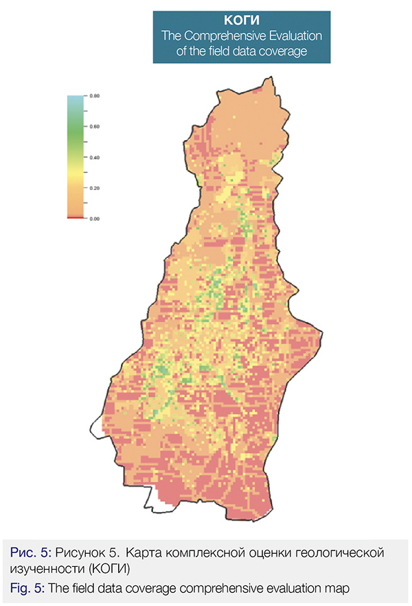
This analysis was carried out for the entire Achimov strata area to define how the area is covered and supported by the geological and geophysical information, ensuring the knowledge of the geological play structure and its properties. The coverage by seismic and well (including drilling, log, test, core, field development) data were considered. Maps were developed based on each of these criteria and their integration made it possible to create the field data coverage map. The resulting map was scaled from 0 to 1 where the index of the field data coverage over 0.65 means that data is sufficient for pilot commercial development, the index ranging from 0.25 to 0.65 means that zonal projects can be prepared for delineating prospective options, and the index of 0.25 means that prospecting projects can be implemented to evaluate the area’s potential hydrocarbon bearing capacity.
The integration of the quantity map, the resource base quality map, the risk map and the field data coverage map resulted in the Achimov Suit Prospectivity Integral map which was the foundation for selecting the key zonal projects for further exploration and the geologic-economic appraisal.
Conclusions
A three-stage approach was elaborated to fill the business portfolio with prospective options. The first stage includes the implementation of the prospective zone regional evaluation. The model becomes actual after the implementation of zonal projects and is used for delineation of less interesting zones. The priority prospective zonal projects represent the second stage – they make it possible to delineate the license areas to evaluate the resources across the entire geological cross-section. And the final third stage means carrying out economic-geological evaluation for ranking the selected options, considering the expenses demanded for the geological prospecting and exploration.
The implemented progressive approach became possible due to the activities carried out to develop the integral regional model which comprised the following information:
• The resource base quantity;
• The resource base quality;
• The geological, technological and economic risks;
• The field data coverage.
A cross-trained team of experts worked on the project including experts from the geological prospecting and exploration expertise, such as geology, seismic, petrophysics, and from some other related disciplines, such as development, infrastructure, economics, and information technologies.
This work resulted in the creation of a business tool for the effective prospecting and evaluation of potential petroleum bearing areas, to replenish and build up the Company’s resource base.
Credits
We express our thanks to the colleagues who took part in the development of the regional model:
A.A.Minich, S.N.Rasskazova, A.I.Sevostyanov, D.V.Solodov, G.M.Timoshenko, E.E.Fattakhov, “Gaspromneft NTC”, LLC , “GPN-GEO”, LLC, FSUE “ZapSibNIIGG”, “NGT Engineering”, LLC.
List of references
1. A.D. Duchkov, L.S. Sokolova Heat Flow in the West Siberia. In “The Methodology and Results of Geothermal Research”. Novosibirsk, 1979, pp.5-16.
2. A.R. Kurchikov B.P.Stavitsky Geothermy of the Oil and Gas Bearing Provinces in the West Siberia. Moscow, Nedra, 1987 p.132.
3. A.A.Nezhdanov Riftogenic model of West Siberian basin as a basis for new oil and gas accumulation zones forecast. Materials of the international symposium “Geodynamic evolution of sedimentary basins”, Moscow, 1992. P.104.
4. V.S. Surkov,O.G. Zhero, L.V.Smirnov Tectonics of oil and gas regions of West Siberia. Main stages of West Siberian plate basement tectonic evolution. Novosibirsk, SNIIGGiMS, 1971. Iss. 132.
5. V.V. Surkov Geothermal characteristic of central part of West Siberian plate platform cover and its connection with geological structure of basement. Issues of exploration and field geophysics in West Siberia, ed. V.S. Surkov, L.A. Sigal. Novosibirsk, SNIIGGiMS, 1972. Iss. 156.
Authors
A.A.Timirgalin, M.G.Butorina, N.O. Novikov (Gazpromneft STC LLC)
G.V. Volkov, I.R.Mukminov, N.A.Parfenov (Gazpromneft – GEO LLC)

