Past and the Future of Geosteering
Conventional geosteering becomes more complex, faster and requires more data in real-time. This puts an incredible amount of pressure on geosteerers as their decisions need to be taken in a shorter amount of time, need to be more precise and require from him/her analysis of a larger amount of data.
But that was not always the case.
A Historical Glance at Geosteering
Many of us remember that just roughly 20 years ago geosteering looked quite different. In the past, horizontal and deviated drilling was relatively simple, slower and allowed enough time to collect and interpret the data and select the direction of drilling. There were relatively fewer logs to look at and fewer changes of well’s inclination.
Conventional geosteering decisions were first based on cuttings, and only LWD log streams like gamma-ray, density, and resistivity (non-azimuthal!) were streamed in real-time.
Geosteerers (or well placement engineers) paid attention to negative and positive drill breaks and had very little information about the subsurface due to a very shallow depth of investigation of these sensors.
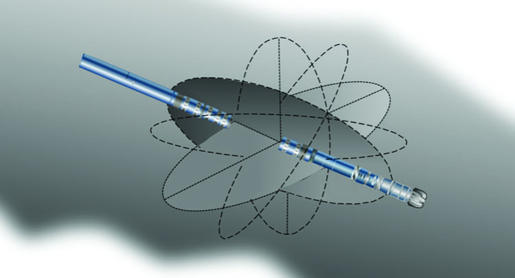
Then, with the introduction of azimuthal measurements (especially density and resistivity logs) and subsequently image logs, geosteering became a state-of-art process to be performed in a three-dimensional environment. The steering commands apart from “up” and “down” included “left” and “right” too (inclination – “up” and “down” and azimuthal “left” and “right” changes of the steering direction).
I myself remember the time when geosteerers stopped paying attention to cuttings (or at least their analysis become less decisive) and focused more on a higher number of more precise (meaning – deeper depths of investigation) LWD image logs first with four sectors, then 8 and even 16 or 32 sectors around the borehole.
Finally, not so long ago, with the introduction of deep directional electromagnetic resistivity tools (“look ahead” of the bit tools) a proactive geosteering was born and the well placement was never the same again.
Simultaneously, the improvement of LWD tools, digitalization, and development of database systems (especially cloud systems) created a situation where bigger and bigger amounts of data could be transferred to the wellsite environment. Regardless of the geographical location (onshore or offshore) an obsolete satellite non-broad band connection used only in case of emergency has been replaced by wireless broadband fast internet available virtually in any place on drilling rigs. High-speed wireless terminals (e.g. RAS-Extend Land Vehicle and RAS-Extend Marine) commonly used across the industry allow for instantaneous real-time database connections and work in synchronized model/project environments across several locations (e.g. Studio repository in Petrel, SLB), something that was quite difficult to imagine just few years ago.
In the area of communication (communication lines between wellsite and in-office support elsewhere) there was also a significant improvement. You don’t need to be that old to remember going to the company’s man office to ask for permission to use the only satellite phone on the rig. It was a real revolution when stationary phone lines were installed on the rigs, and emails became a common way of conveying information.
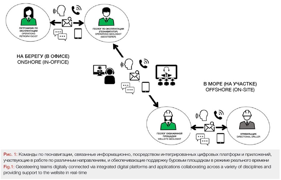
Nowadays, video streaming between the involved parties is not uncommon. More, the recent virtual teams and virtual office concept pushed for the creation of digital virtual collaboration facilities (e.g. ACE – Advanced Collaborative Environment at BP) and even bigger regional and global collaboration centres. This is where the employees although located a thousand miles away from each other can obtain a feeling of being located in the same office, desk to desk. They are also digitally connected (via integrated digital platforms and applications) and collaborate across a variety of disciplines providing support to the wellsite in real-time (see figure 1). This significantly shortens the decision-making process resulting in a more efficient and effective geosteering process.
Digital Transformation Era
With the onset of the digital transformation era, exponential development of a variety of data solutions resulted in an increase of potential data sources feeding more efficient databases (efficiency of data storage, access, filtering, sharing, cloud solutions, etc.), shorter data collection and processing time, and the faster time needed for their robust analysis and the subsequent results sharing. Additionally, a need for merging the real-time data with the existing (previously gathered) data from e.g. offset wells was also addressed and is already available. With the adoption of Artificial Intelligence and Machine Learning, the data analysis process and their application will soon have no limits. An integrated well-informed decision-making process that involves a virtual multidisciplinary team operating within the digital environment will soon take over the geosteering for good.
But the future revolution in geosteering (and drilling) is yet to come.
The Integrated Well-Informed Decision-Making Process
In the past, making an error because of wrong data interpretation (meaning: incorrect data analysis) or due to too slow decision-making process (resulting from lack of data, lack of support, slow data collection, processing or sharing, etc.) and choosing an incorrect direction for steering was quite reversible and not absolute. Relatively slow drilling process mitigated slow reaction time and eventual correction of the drilling angle was achievable.
The risk of wrong well placement (meaning: the risk of wrong inclination decision) was distributed across the drilling time and was related to:
• limited data available for making decisions (guessing, hints, premonitions),
• decision-making process inefficiency (not suitable processes, traditional obsolete organizational setup, lack of support),
• inefficient and not adequate communication lines
Currently, the risk of incorrect well placement remains equally high, but it results not from limited data, inefficient decision-making process of poorly designed communication lines, but from extremely small margins allowed for mistakes and from the need for an extremely fast decision-making process. The process of data collection from a variety of sources, data processing, and analysis, cross-checking with the model, results sharing and distribution across the multidisciplinary team and finally making an integrated well-informed decision about inclination change needs to occur in a matter of minutes! And then sending the downlink to the tool with the new inclination target must happen within these few minutes as well.
Nowadays, no one has the comfort of making a mistake and then correcting it. The world of lower margins in the oil and gas industry, extremely high drilling cost, and fluctuating oil prices made companies unable to afford placement outside of the pay zone, re-drilling or sidetracking. Not anymore. The budgets are tighter and tighter.
Digital Situational Awareness
This is when the next geosteering revolution comes to the stage.
An operator who possesses an advantage in the amount of information collected from multi-sources, then processing, analysing, integrating and transmitting it faster than others will win the race. Everyone who provides real-time data that covers a bigger «chunk» of the subsurface environment than others and is then able to analyse it properly in real-time and communicate it across their multidisciplinary teams with sufficient speed and ultimately send a correct command to the tool will win (figure 2).
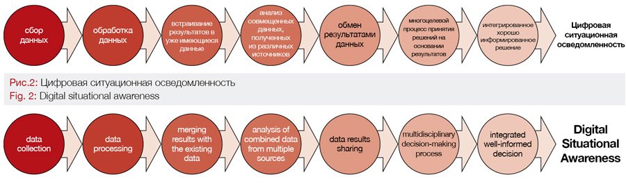
This capability is called digital situational awareness and covers all the information collected about the three-dimensional subsurface environment available at any given point for interpretation that can be used for well-informed decision-making process.
The process includes following steps:
• Data collection,
• Data processing
• Merging the results with the data already possessed (stored e.g. offset wells data)
• Analysis of combined data from multiple sources
• Data results sharing
• The results presented in a simple and digestible form to all sites in real-time
• Multidisciplinary decision-making process based on the results
• The result – integrated well-informed decision
• Digital situational awareness is obtained at any given point of the geosteering process
Situational awareness is the perception of environmental elements and/or events with respect to time and space, the comprehension of their meaning, and the projection of their future status. Situational awareness can be defined simply as “knowing what is going on around us” or – more technically – as the perception of the elements in the environment within a volume of time and space, the comprehension of their meaning and the projection of their status in the near future.
Situational awareness obviously also needs to cover the biggest three-dimensional subsurface space as possible that a well is being drilled through and be as detail as possible. Situational awareness is a base for making all geosteering decisions. Being aware of the subsurface environment a well drills through at any given point of the drilling process creates a situation where one is consciously able to make a decision about whether to steer up or down. And it is no longer guesswork, rather it is a well-informed decision being taken consciously and based on a full 360 degrees three-dimensional detailed picture of the subsurface environment.
With this modern informational-situational awareness, the one who has an advantage over the others and drills the most optimally placed well, at the same time in the fastest and the cheapest way will win.
This is the future.
Author: Piotr Przybylo, GeoModes

About the Author
PIOTR PRZYBYLO has acquired crucial technical and business skills that enabled him to drill some of the deepest and longest wells in the world. He bridges the gap between the technical and commercial sides of the upstream oil and gas industry. He is the Founder of GEOMODES, a company that educates future experts in the field of geosteering and optimizes team organizational structure for efficient skill utilization. He is also the author of HORIZONTAL WELL GEOSTEERING GUIDELINES (Amazon)- first ever published comprehensive manual which is a must-have for every geosteering expert.
Reach out to author: piotr.przybylo@geomodes.com
Previous articles:
Why Collaboration has a Higher Impact on Business Performance than Technology
Introducing Geosteer Well On Paper™ A New Important Step in the Well Delivery Process