Rosgeology Performed Airborne Geophysical Surveys in East Antarctica on an Area of Almost 15,000 km2
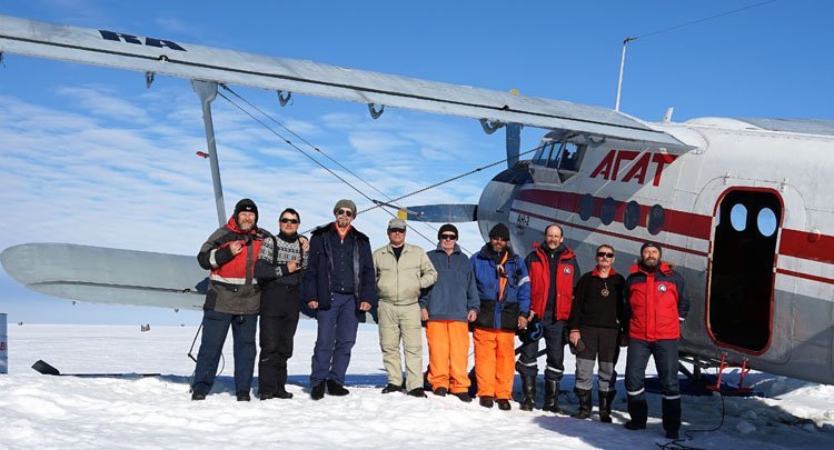
Specialists of JSC Polar Marine Exploration Expedition (PMGE, a subsidiary of JSC Rosgeologiya) have successfully completed field airborne geophysical work in East Antarctica, provided for by the program of the 65th Russian Antarctic Expedition (RAE).
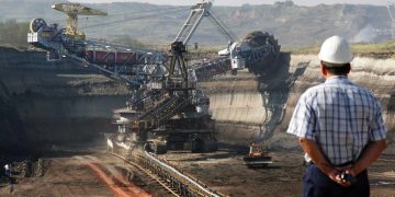
From January to March 2020, the airborne geophysical detachment of the Antarctic Geophysical Party PMGE, as part of the state contract, conducted a comprehensive airborne geophysical survey at a scale of 1: 500,000 at a range of almost 15,000 km2 in the southwestern part of the Queen Mary Land. The work included aeromagnetic surveying and radar sounding of glaciers and was carried out from the AN-2 aircraft based on an ice airfield near the Russian Antarctic station Mirny. During the season, 35 routes were completed with a total length of 5490 linear meters. km
Polygon shooting situated on the slopes of the East Antarctic ice sheet with a height difference of the surface from 1350 m to 2150 m. FLIGHTS performed at a constant altitude of 2200 m. Despite the extremely bad weather (in midsummer temperature is not more than -15 on with constant wind 15 -20 m / s), as well as the remoteness of the work area from the base (up to 270 km), which required a lot of time for approaching, the airborne geophysical survey was carried out in full.
According to radar sensing data, the studied area is covered by a glacier with a thickness of 500 m to 2500 m, and the under-ice relief is mainly represented by a hilly plain, in the west and in the center of which there are depressions with a depth of 600-700 m below sea level. According to magnetometry, a crystalline basement, composed of weakly magnetic metamorphic rocks, lies over the entire area. On the eastern border of the geophysicists’ range, mountains were found with steep slopes and peaks of 1200-1400 m above sea level, broken by deep canyons. It is assumed that this mountain system is an under-ice continuation of the Obruchev Mountains, framing the glaciers of the “Scott Rift System” from the west, which the airborne geophysical detachment PMGE plans to start mapping during the next 66th RAE.
“The completed field work is the continuation of many years of domestic research of Antarctica, during which more than 700 thousand linear meters were taken only by airborne geophysical surveys. km in the coastal strip of almost half of the mainland, ”said Sergey Kozlov, chief geologist at PMGE, doctor of geological and mineralogical sciences. “Nevertheless, the vast areas of East Antarctica, hundreds of thousands of square kilometers, still remain a white spot, we are less aware of their geomorphology than the topography of the ocean floor or the surface of the moon, and only airborne geophysics can gradually fill these gaps.”
Reference:
Специалисты и оборудование ПМГРЭ, пилоты авиаотряда и самолет Ан-2 в разобранном виде для проведения аэрогеофизических работ в рамках 65 РАЭ были доставлены на станцию Мирный в конце декабря 2019 года научно-экспедиционным судном «Академик Трешников». В конце марта 2020 года НЭС «Академик Федоров» приступило к эвакуации сезонного состава участников 65 РАЭ с российских станций, в т.ч. забрало со станции Мирный специалистов и оборудование аэрогеофизического отряда ПМГРЭ. В середине апреля исследователи Антарктиды отправятся со станции Новолазаревская в порт Кейптаун (ЮАР), а затем вернутся в Россию.
JSC Polar Marine Exploration Expedition is a specialized company that performs comprehensive geological and geophysical studies of the geological structure of the subsoil and searches for minerals in all the most inaccessible regions of the Earth: the Arctic, Antarctic and the World Ocean. PMGE has three field bases in Antarctica and a field base on the Spitsbergen archipelago.
Rosgeology is a Russian multidisciplinary geological holding company that provides a full range of geological exploration services: from regional studies to parametric drilling and subsoil monitoring. The holding has unique competencies, including in the field of marine geology and offshore operations. Holding enterprises have discovered more than 1000 deposits, among which are the largest deposits of hydrocarbons and solid minerals. 100% of the shares of Rosgeology JSC are owned by the state.