The Geological Systems of the Oil Rim Fields in the Urengoy Region
The Oil rims at the fields in the Urengoy region contain significant oil reserves, and the issues of their development have now acquired particular relevance. One of the main factors determining the successful development in such a complex geological region is to have the correct understanding of the internal structure and distribution pattern of the traps in the hydrocarbon system. This understanding can be achieved only by tracing the history of the formation and the subsequent transformations of the oil and gas deposits.
Non-Horizontal Position of Gas-Oil and Oil-Water Contacts
In many fields of the Urengoy region, the complex geological structure of the Neocomian strata is primarily due to the non-horizontal position of the gas-oil and oil-water contacts. So, at the En-Yakhinskoye field the BU8-9, BU102, BU111 and BU121 formations and at the Pestsovoye field, in the BU92-4 formation, according to the test and well logging data, the fluid contacts are inclined in one direction, namely from the west to East. At the same time, the difference in the hypsometric position of the Gas Oil Contact (GOC) and the Oil Water Contact (OWC) is very significant and reaches 20 m and more. Such significant deviations in the distribution of water, oil and gas in the modern structural traps from the known principles of the anticlinal-gravitational concept hydrocarbon deposits formation requires a convincing explanation. Multiple researchers (II Nesterov [3], VS Bochkarev, VN Borodkin, AR Kurchikov [2], Yu. Y. Bol’shakov [1], VA Skorobogatov, LV Stroganov [4] and others).
Most of the authors considered the following main factors that affect the distribution of liquid and gaseous hydrocarbons in traps: tectonic, lithological, movement of artesian waters, sealing of deposits at the boundaries of oil with water and gas with asphaltenes and resins, capillary forces, etc. Let us consider which of the named factors are decisive and assess their influence on the formation of oil rims using the example of an oil and gas deposit at the En-Yakhinsky and Pestsovoye fields. At the En-Yakhinskoye field, we will consider the reservoir formation BU121, which has the greatest slope of fluid contacts, which is about 25 m.
Paleotectonics
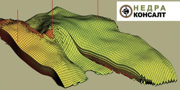
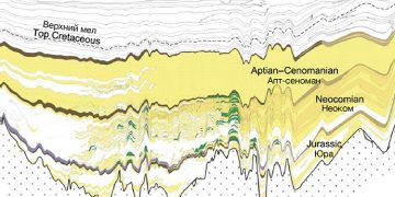
Assessing tectonic factor influence, we note that in the opinion of most researchers, modern hydrocarbon deposits began to form already in the Lower Cretaceous and, in earlier periods, underwent various transformations following the shifting tectonic conditions of the region. To study the history of formation and re-formation of deposits in the BU121 formation of the En-Yakhinskoye field, we constructed paleoprofiles in the direction of the contact slope – from west to east along the line of wells 610P, 463P, 483P, 467P and 603P (Fig. 1).
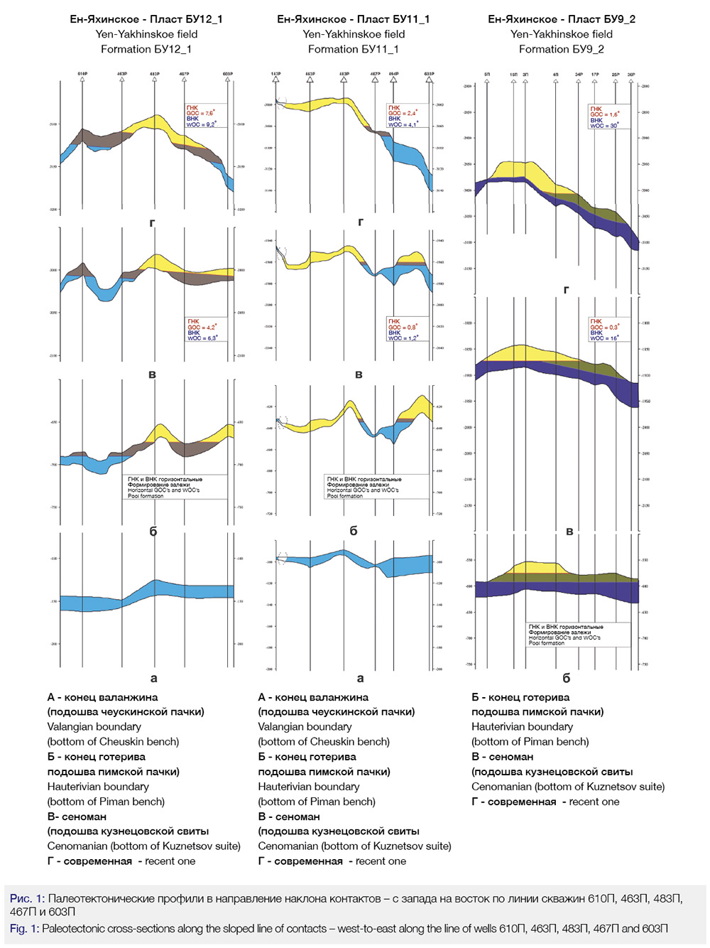
As can be seen in profile b, at the time of the BU121 structure formation – the end of the Hauterivian, the En-Yakhinskaya trap had a three-domed structure, and the central and eastern domes are practically the same in height and, presumably, control deposits with gas caps underlain by the oil section.
In the Upper Cretaceous, the structural plan changes significantly (profile c). The western dome increases in size and amplitude. The eastern part of the trap is submerged, and the amplitude of the eastern dome is significantly reduced. Obviously, during this period, there is a tilt of the interphase sections and a redistribution of hydrocarbons in the trap, part of the gas from the eastern submerging dome moves to the central dome, displacing oil into the peripheral parts of the structure. In the Late Cretaceous and Paleogene-Quaternary (profiles c and d), the trap transformation tendencies are generally preserved, the eastern wing of the fold continues to descend with great intensity, the eastern dome flattens out and completely disbands during this period, and a monoclinal slope. The oil and gas in the eastern dome apparently migrated towards the central and western domes.
Most researchers agree that the modern structural plan was formed in the recent Pliocene-Quaternary. This means that the hydrocarbon deposits formed because of the migration that occurred at an even earlier time and, possibly, continues to this day [4, 5].
Considering the above, wells 603P and 600P located in the eastern part of the field are of interest. During the tectonic development of the territory, they were in different structural conditions. Thus, in the paleoplane, at the end of the Hauterivian time, well 603P was located within the gas-bearing contour in the vault of the eastern dome, which complicates the En-Yakhin structure. Well 600Р, located 3.0 km to the south, unlike well 603Р, during this time period was located significantly hypsometrically lower, outside the eastern dome in the aquifer. It is assumed that in the process of the reformation of the reservoir that hydrocarbons from the eastern dome, during its disbandment, migrated to the central dome, which continued to grow.
To confirm this position, which is of fundamental importance to explain the modern structure of the reservoir, we compared the indicators of the residual oil and gas saturation of the BU121 formation for the wells under consideration. In well 603R, according to logging data, the value of the residual oil and gas saturation of the reservoir reservoirs is 56%, which is a fairly high indicator; during testing, an insignificant gas inflow was obtained from the reservoir. In well 600R, the oil and gas saturation factor is significantly lower and amounts to about 28%; no inflow was obtained during testing. In our opinion, the high residual oil and gas saturation of the BU121 formation in well 603R, as compared to well 600R, is explained by an episode of the presence of a gas (gas-oil) deposit during the geological history in the area of well 603P.
Intra-Reservoir Oil and Gas Migration
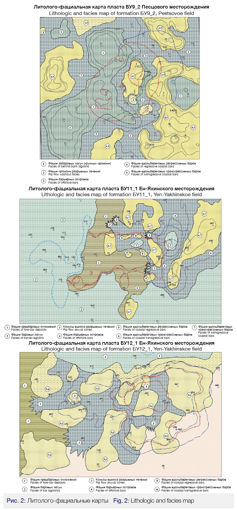
Next, we will consider the process of intra-reservoir migration of oil and gas from the eastern dome as it sinks and opens intensively. As noted earlier, this process most likely took place in recent geological times. Obviously, gaseous and liquid hydrocarbons, according to the anticlinal-gravitational concept of reservoir formation, tend to fill the most elevated sections of the trap, and the gas-oil and oil-water contacts take a horizontal position. The very process of intra-reservoir hydrocarbon migration under the action of gravitational forces directly depends on the structure of the reservoir and the hydrodynamic connectivity of the permeable interlayers. To assess the influence of these factors, we built a lithological-facies model of the BU121 formation. As can be seen on the lithological-facies map (Fig. 2), the reservoir is characterized by significant facies variability, and there is a clear zoning of the distribution of various facies in the rocks. In general, the BU121 formation is represented by sediments of shoreline transgressive and regressive bars, elongated in chains in the submeridian direction. Bar formations are cut by facies of discontinuous currents, represented by alluvial deposits, which form zones of predominantly submeridian direction.
Obviously, the boundaries between facies formations of different genesis represents certain barriers, where the hydrodynamic connectivity of the permeable layers of a productive formation can be significantly hampered. This position is illustrated by the geologic profile shown in Figure 3, showing the relationship of permeable sands in the various intersecting facies zones, at the boundaries of which the hydrodynamic connectivity of the sands may deteriorate.

Changes in Reservoir Properties
An important factor affecting the distribution of hydrocarbon fluids in traps during reservoir reformation is the reservoir properties and the nature of their change over the area. Let us consider the influence of this factor on the formation of the formation BU121. Figure 4 shows the porosity map of the BU121 formation obtained as a result of 3D geological modeling. The map shows that the zoning of the reservoir porosity change, as well as the lithological-facies zoning, has a clear submeridional direction. In the eastern part of the reservoir, where the most hypsometrically low GOC and OWC marks were penetrated by the wells, the map shows the field of the highest values of the reservoir porosity coefficient (the area of wells 455P, 500P, 450P, 457P), varying from 14.5% to 16.5%. To the west, there is a clear submeridional zone of low porosity values (the area of wells 451P, 473P, 352, 498P), where the values of this parameter are significantly lower and amount to 12.5% -14.5%.
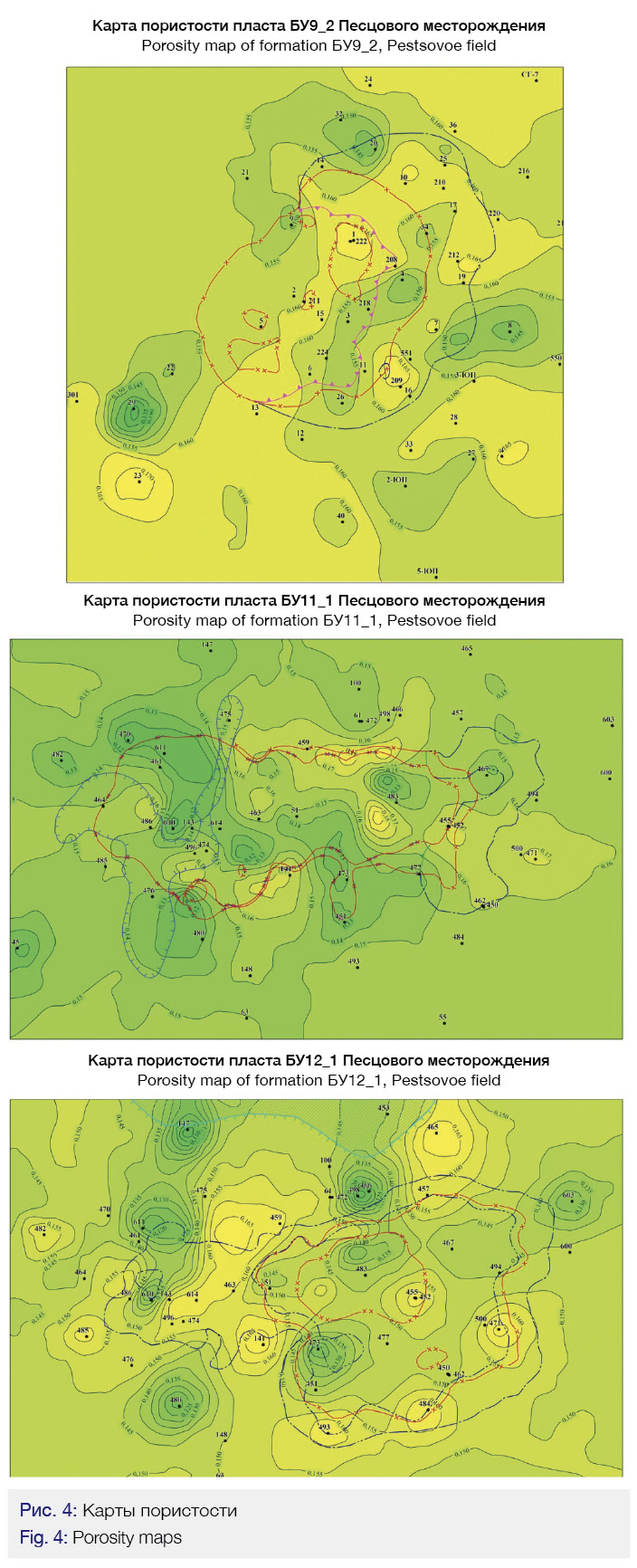
Further, in the western direction, one can see the alternation between zones of increased and decreased porosity. The next submeridional zone of increased porosity values (from 15.0% to 16.5%) (area of wells 141P, 134, 1050), is limited from the west by a zone of decreased values of 12.0% -14.5% and is characterized by a higher position of contacts, compared to the eastern section of the deposit.
Let us consider how the lithological-facies heterogeneity and variability of the reservoir-filtration properties influenced the redistribution of oil and gas during the tectonic restructuring of the trap in the BU111 formation. As can be seen on the paleotectonic profiles (Fig. 1), by the end of the Hauterivian time, when, as mentioned earlier, the En-Yakhinskaya trap was formed, two HC accumulations probably formed in the stratum – in the central and eastern domes.
In the subsequent geological time, the growth of the central dome and the intensive subsidence and flattening of the eastern dome, up to its full opening, are observed, which caused the flow of hydrocarbon fluids upward along the rise of the layers into the central dome, the capacity of which increased due to the uplift of the western wing. The oil contained in the paleo-deposit of the eastern dome migrated up the uprising of the layers and this process also completely depended on the internal structure and heterogeneity of the reservoir-filtration properties of the reservoir. To study these factors that determine the dynamics of hydrocarbon migration, a lithological-facies map of the BU111 formation (Fig. 2) and a reservoir porosity map (Fig. 4) were built.
Lithologic-Facies Variability
As can be seen on the presented maps, the BU111 layer is characterized by sharp lithological-facies variability, which has a clear submeridional direction. On the way of HC migration from the eastern dome, the facies of alongshore bars, distinguished in the area of wells 603P, 494R, are replaced by facies with ruptured currents, facies with deep-water gullies, and, finally, facies of pre-bar deposits. Corresponding to the change in the facies environment, in the direction from east to west, the reservoir-filtration properties of the reservoir sharply deteriorate (Fig. 2), up to a complete clay formation.
Similar processes of reformation of deposits took place at other fields in the Urengoy region. The most significant restructuring was the BU92 reservoir at the Pestsovoye field. As can be seen on the paleotectonic profiles (Fig. 1), the eastern wing in the Late Cretaceous and Cenozoic times subsided with increasing intensity. Obviously, the oil and gas reservoir continued to be replenished with gas, which, as a much more mobile phase, displaced oil from the crest of the structure. Oil, screened by gas and submeridional facies barriers (Fig. 2, 4), formed a “canopy” rim on the eastern plunge of the structure with an OWC inclination of about 300. Submeridional zoning of lithological and facies The reservoir-filtration characteristics of the reservoirs complicate the redistribution of hydrocarbons and the establishment of a horizontal position of contacts during the tectonic transformations of the traps. The analysis of the dynamics of the tectonic processes showed that the traps that control the deposits are still undergoing restructuring.
It was found that the tectonic forces tilt the interfluidal sections with a greater intensity than gravitational forces are able to give a horizontal position to the contacts, overcoming the resistance to hydrocarbon migration caused by the lithological-facies heterogeneity of the formation. The foregoing is true for all deposits of the En-Yakhinskoye and Pestsovoye fields with an inclined position of the GOC and OWC.
Paleotectonic and lithological-facies constructions, performed on the layers of the En-Yakhinsky and Pestsovoye fields, allow us to draw the following conclusions:
1. Traps of hydrocarbon deposits after their formation, as a result of multidirectional tectonic movements in the Late Cretaceous – Cenozoic geological time, underwent significant structural changes.
2. The restructuring of traps led to the reformation of deposits as a result of intra-reservoir secondary migration of oil and gas, which possibly, continues to this day.
3. Lithological-facies heterogeneity of formations has a clear submeridional zoning and determines the presence of zones of difficult hydrodynamic connectivity of permeable layers of productive formations confined to interfacial boundaries.
4. Ongoing tectonic restructuring of the traps and high lithological-facies heterogeneity of the formations prevents gravitational forces from bringing the position of the interfluidal sections to a horizontal position and determines their inclined position, to a lesser extent gas-oil (water) and to a greater extent – water-oil.
The results obtained made it possible to better understand the geological mechanisms and dynamics of the formation of oil and gas deposits with inclined fluid contacts. The knowledge gained was applied in their geological modeling, which made it possible to increase the efficiency of work on their further study and development planning.
Bibliography
1. Bolshakov Yu.A. The theory of capillarity of oil and gas accumulation. Novosibirsk: Nauka, 1995, p.184;
2. Borodkin V.N., Kurchikov A.R. Geological structure and prospects of oil and gas content of the Achimov strata in the North of Western Siberia. – Novosibirsk: Publishing house SO AN, 2010, p.134;
3. Nesterov I.I., Salmanov F.K., Shpilman K.A. Oil and gas fields in Western Siberia. Moscow: subsoil, 1971, p.462;
4. Skorobogatov V.A., Stroganov L.V., Kopeev V.D. Geological structure and oil and gas content of Yamal. Moscow, 2003, p.350;
5. Khromovskikh A.Yu. The nature of inclined oil-water contacts of the Upper Jurassic oil deposits of the Kaimysov arch. – Tomsk, Bulletin of the Tomsk Polytechnic University, T 320, No. 1, 2011, pp. 130-133.
Authors
Evgeny Popov – CEO (Nedra-Consult LLC)
Yuri Stovbun – Deputy Chief Geologist (Nedra-Consult LLC)
Vitaly Korzh – Head of the Licensing and Exploration Department (Nedra-Consult LLC)
Leonid Lobanov – Geological engineer of the Geological Exploration Analysis and Design Sector (Nedra-Consult LLC)